Austro-Hungarian Empire
Austria - Austria, Styria and Tyrol 1882
Banat Region - central Hungary 1882
Bohemia 1882
Galicia 1882
Moravia 1882
Northern Hungary 1882
Transylvania - Eastern Hungary 1882
Western Hungary 1882
Austria Hungary 1887
Krakau (Krakow) city plan, 1890s
Austria and Western Hungary North 1908
Austria and Western Hungary South 1908
Eastern Hungary and Galicia 1908
Austrian Tyrol 1908
Torontal, Banat 1910
German Empire
Alsace-Lorraine 1882
Baden-Wuerttemburg 1882
Northern Bavaria 1882
Southern Bavaria 1882
Brandenburg - Prussia 1882
Brunswick, Lippe-Detmold, Schaumburg-Lippe, etc. 1882
East Prussia 1882
Hanover - Prussia 1882
Hesse-Cassel and Hesse-Darmstadt 1882
Mecklenburg-Schwerin - Mecklenburg-Strelitz 1882
Pomerania - Prussia 1882
Posen - Prussia 1882
Rheinland - Prussia 1882
Kingdom of Saxony 1882
Prussian Saxony 1882
Schleswig-Holstein 1882
Silesia - Prussia 1882
West Prussia 1882
Westphalia - Prussia 1882
Western Germany North 1908
Western Germany South 1908
Eastern Germany North 1908
Eastern Germany South 1908
Russian Empire -- Europe
The Baltics - Lithuania, Latvia and Estonia 1882
Belarus 1882
Russia - Northwest 1882
Russia - Southwest 1882
Ukraine and Bessarabia 1882
Russia - Northeast 1882
Russia - Central East 1882
Russia - Southeast 1882
Russia - Volga and Don River Basins 1882
Russia - Caucasus 1882
Russia - The Crimean Peninsula 1882
Russia in Europe 1887
Russia - Evangelical Lutheran Consistories of Russia
The Polish Provinces of the Russian Empire 1902
Russia in Europe North 1908
Russia in Europe South 1908
Central and South Russia West 1908
Central and South Russia East 1908
Russian Empire -- Asia
The Trans-Ural Steppe 1882
Northern Yakutsk 1882
Northern Yenisesk Guberniya 1882
Northeast Northern Far East
South Central Siberia 1882
Southwest Siberia - Tobolsk Guberniya 1882
Southern Far East - Southern Maritime Provinces, Sakhalin 1882
Russia in Asia 1887
Asiatic Russia (Siberia) West 1908
Asiatic Russia (Siberia) East 1908
Central Asia West 1908
Central Asia East 1908
Balkans
Bosnia - Herzegovina 1882
Bulgaria and Eastern Roumelia 1882
Northern Greece, Macedonia, Albania 1882
Southern Greece excluding Crete 1882
Romania - Moldavia 1882
Serbia and Montenegro 1882
Romania - Wallachia 1882
Balkans 1887
Croatia: Vivodina District
Turkey in Europe West 1908
Turkey in Europe East 1908
Greece West 1908
Greece East 1908
Asia Minor and Armenia West
Asia Minor and Armenia East
Hutterite Map Collection
16th Century Europe - West
16th Century Europe
South Tirol | Placenames
South Tirol - East | Placenames
Moravia and West | Placenames
Slovakia and East
Scandinavia
Finland 1882
|
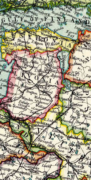
Detail from the 1908 map of
Central and South Russia West
Most of the maps in this collection came from two important sources -- an atlas published by Blackie & Sons in Edinburgh, Scotland, in 1882, and the Harmsworth atlas published in London in about 1908.
Maps are vital to genealogical research, so we are continuing to search for new ones to add to what is available on this site.
Further resources:
Using Maps and Gazetteers In Your Research
by Dave Obee
Two centuries of Atlases
The history of modern cartography 1800-2000
Partial Gazetteer to the Harmsworth Atlas
JewishGen ShtetlSeeker
Getty Thesaurus of Geographic Names Online
Kartenmeister
for finding places in the former German empire
Other map sites:
American Geographical Society Collection
University of Wisconsin-Milwaukee Library
Perry Castañeda Historical Map Collection
University of Texas libraries
David Rumsey Collection
More than 13,600 maps online
Central and Eastern Europe
Maps from 1896 to 1967
|